


Province maps out route for new GTA highway
The Ontario government has mapped out its preferred route for a new 400-series highway through the Greater Toronto Area.
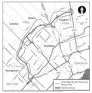 The highway has been dubbed the GTA West corridor. The preferred route laid out by the province on August 7 sees the highway run southwest from Highway 400 in Vaughan, through Bolton and Brampton, before heading south and ending at the junction of Highway 401 and Highway 407 in Mississauga.
The corridor will include a four-to-six lane 400-series highway, separate infrastructure dedicated for transit and passenger stations, as well as intelligent transportation features and truck parking. By 2031, the overall traffic on the route is expected to exceed 300,000 auto vehicles trips per day.
"The Greater Golden Horseshoe is an economic driver for the province and addressing transportation needs in this region is essential to the competitiveness of our economy," said Caroline Mulroney, Minister of Transportation. "The GTA West Corridor will help alleviate traffic congestion and improve the movement of people and goods across the province."
The project has been the subject of a series of on-again, off-again developments. The proposal was quashed by the previous Liberal government before being restored by the current Conservative government last summer.
Further design work for the project will occur over the next two years, and the environmental assessment is expected to be complete by the end of 2022.
- Government
- Projects
- General Industry